|
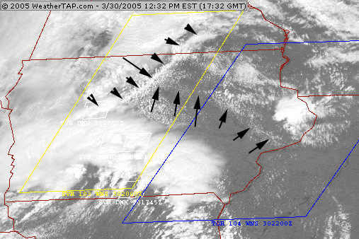
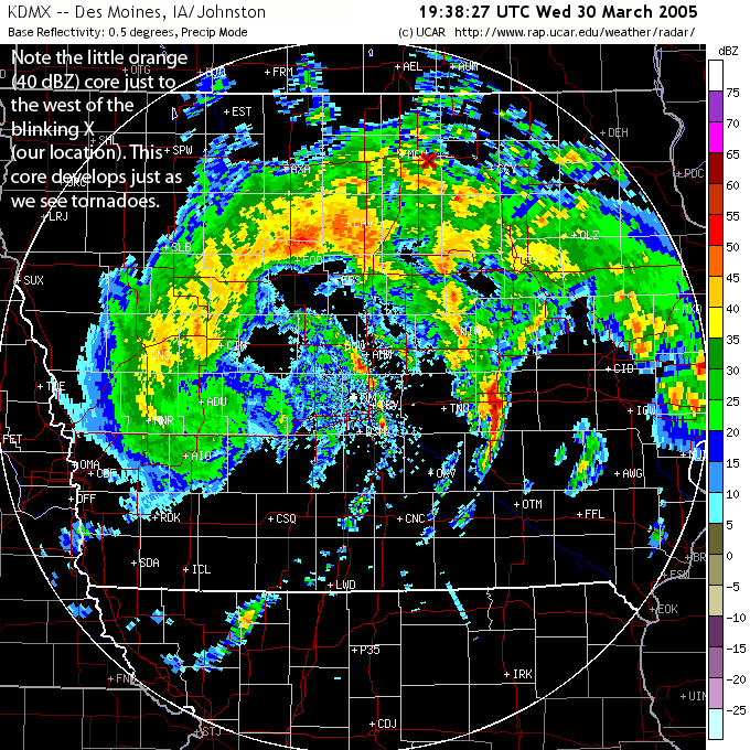
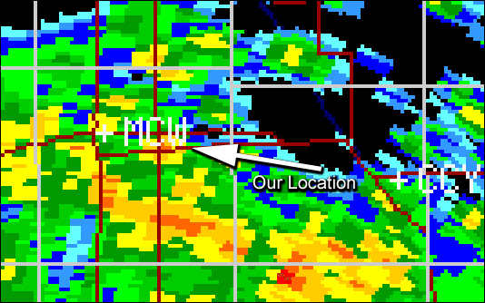
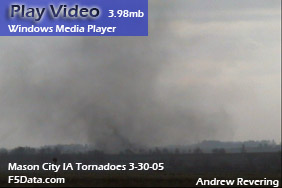
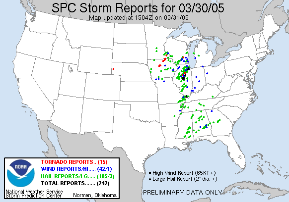
Beau Gjerdingen and myself left St Cloud about 630 am and picked up Erin Beilke in Rogers when we got a call at the last minute from Shawn Hewitt. Shawn decided he'd like to go (with a little encouragement from us), and he offered to drive with his van. So we went to Woodbury and picked him up and then got Joel Lampe down in Bloomington. Pretty full load but with gas prices around $2.10 a gallon, it was worth it to split the costs. Our target location was around the Webster City/Clarion, IA area. We got down to Clear Lake and saw a line of thunderstorms coming up on a boundary. Not sure if it was a warm front though because there was a dry slot north of the warm front with temps in the 70s where we were. Everything was backwards this day, including the tornadoes. The tornadoes were ahead of the cells on radar (which were very minimal in intensity). In any case, we waited it out, drove in a circle a couple times and eventually came across the tornadoes 4.9 miles southeast of Mason City. See map below.
958
WFUS53 KDMX 301944
TORDMX
IAC033-302015-
/O.NEW.KDMX.TO.W.0004.050330T1943Z-050330T2015Z/

BULLETIN - EAS ACTIVATION REQUESTED
TORNADO WARNING
NATIONAL WEATHER SERVICE DES MOINES IA
143 PM CST WED MAR 30 2005

THE NATIONAL WEATHER SERVICE IN DES MOINES HAS ISSUED A

* TORNADO WARNING FOR...
  NORTHERN CERRO GORDO COUNTY IN NORTH CENTRAL IOWA.

* UNTIL 215 PM CST.

* AT 138 PM CST...NATIONAL WEATHER SERVICE DOPPLER RADAR WAS TRACKING
  A SEVERE THUNDERSTORM WITH A CONFIRMED TORNADO NEAR MASON CITY. THE
  STORM WAS MOVING NORTH AT 20 MPH.

* THE TORNADO WILL BE...
  NEAR PLYMOUTH BY 150 PM CST.

AT 140 PM...SPOTTERS REPORTED A TORNADO ONE MILE EAST OF MASON
CITY...MOVING NORTH AT 20 MPH.

THIS IS A HAZARDOUS SITUATION. SEEK SHELTER IN A BASEMENT...OR IN AN
INTERIOR ROOM. STAY AWAY FROM WINDOWS. IF YOU ARE OUTSIDE OR IN A
CAR...SEEK SHELTER IN A REINFORCED BUILDING.

LAT...LON 4304 9344 4304 9303 4326 9304 4325 9345


Other chase accounts:
|