|
Shawn Hewitt, Bob Conzemius, Joel Lampe and I teamed up for the best chase in 2006. Shawn offered to drive his van, so I picked up Bob Conzemius a little after 8 a.m. and met at Shawn's place. We then met Joel in Lakeville around 8:40 a.m. and went south on 35 and west on I90. This day had a lot of promise, as it was a remarkable setup with some of the most incredible shear parameters that many of us have seen in years, if not in our chasing experience. 500mb winds were howling just over 90 knots at its speed max! See the archived data. I was excited to try out my Sprint data card now that it seemed data roaming on the AllTel network had been mostly implemented. We got to around Jackson and for some reason it went from Sprint to roaming. I didn't mind that it wasn't using the Sprint network which is what area I was in, because it worked roaming! From here on out we had pretty good data roaming on the AllTel network with the Sprint data card throughout our chase well into southeastern South Dakota. We had been trying to meet up with a couple of Bob's friends, Shaun Kelly and Craig (forgot last name). We met up with Craig somewhere in SW MN or near Sioux Falls, and we travelled to just west of Sioux Falls to the city of Hartford. Here we turned off and cooled our heels a bit. One concerning thing was that the Sioux Falls radar wasn't updating. Craig had friends at FSD, and gave them a call. He found out that the Azimuth motor went out on their radar, and they were a bit frantic trying to get it back up before the event started. They knew the conditions were favorable for a big event, and they had to decide how they were going to proceed with the day's warning responsibilities. This was bad news for the FSD warning area, but fortunately I think things turned out well, at least in part due to the large quantities of chasers out there helping to report things for them while the radar was down. The word was that they didn't think they'd have the radar back up until after 6pm at the earliest! It turned out they did get it back up around 5 p.m. Until then, we decided we would use the long range base reflectivity scan from Aberdeen, and KELOLand Television radar, which would have a lower atmospheric scan to work with. Our strategy for the day was to give everyone in the vehicle a chance to look at data, make their own decision on what they thought we should target, and then when we were done, argue our areas to try to change each other's minds. If we couldn't agree, then we'd just take a weighted average of our targets and compromise. This worked out spectacularly as there was nominal disagreement on the precise place to park.
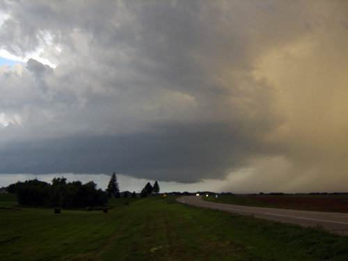
A couple wanted to go somewhere Southeast of Mitchell, a couple wanted to go farther north, perhaps Northeast of Mitchell. We decided to drift west a hair, and north a hair in the middle of our targets, north of Salem. While we were doing this I was having sporadic data issues, but it was trickling in. One trickle revealed a 'blip' on radar, using the long range Aberdeen scan. I questioned it a bit since it was so far from Aberdeen, but it was in the perfect spot, on the boundary, and where RUC had initiated precip in it's forecasts. So we drove to the north side of Salem where data came back in, stopped to see what it was going to do, and a couple more scans made it evident that this was going to be the show! 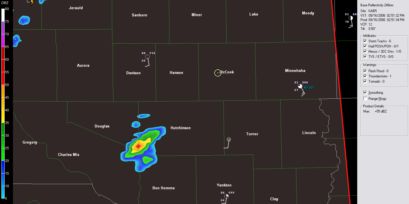
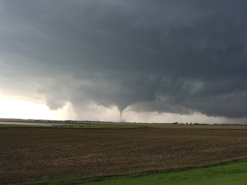
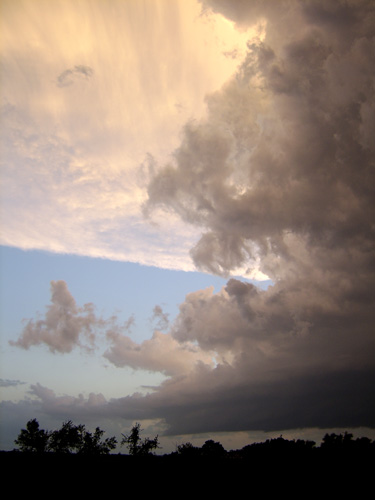
Near Bridgewater, the storm started to take better appearance again.
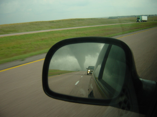
A little farther down the road, near Colton we had another brief tornado:
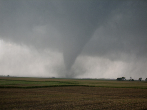
PUBLIC INFORMATION STATEMENT NATIONAL WEATHER SERVICE SIOUX FALLS SD 250 PM CDT MON SEP 18 2006 ...DAMAGE SURVEYS COMPLETED FOR MCCOOK COUNTY AND COLTON AREA TORNADOES... THE NATIONAL WEATHER SERVICE IN SIOUX FALLS HAS COMPLETED THE DAMAGE SURVEY FOR BOTH THE MCCOOK COUNTY AND COLTON AREA TORNADOES THAT OCCURRED ON SATURDAY, SEPTEMBER 16TH. THESE DAMAGE SURVEYS WERE ALSO CONDUCTED IN COOPERATION WITH THE EMERGENCY MANAGEMENT OFFICES FOR MCCOOK AND MINNEHAHA COUNTIES. UPON THE COMPLETION OF THESE SURVEYS...IT WAS DETERMINED THE TORNADO THAT OCCURRED IN MCCOOK COUNTY RESULTED IN A 12 MILE LONG DAMAGE PATH AND WAS ON THE GROUND FOR AROUND 20 MINUTES. THREE FARMSTEADS WERE AFFECTED BY THIS TORNADO...AS WELL AS MOTORISTS TRAVELING ALONG INTERSTATE 90. NO INJURIES RESULTED...BUT AT LEAST FIVE CATTLE WERE KILLED. BASED UPON THE DAMAGE THAT WAS SEEN...THIS TORNADO WAS RATED A F2 ON THE FUJITA SCALE...MEANING WINDS SPEEDS BETWEEN 113 AND 157 MPH OCCURRED WITH THE TORNADO. A DAMAGE SURVEY WAS ALSO CONDUCTED IN NORTHWEST MINNEHAHA COUNTY. THIS TORNADO OCCURRED FOUR MILES NORTHEAST OF COLTON AND WAS ON THE GROUND FOR APPROXIMATELY THREE MINUTES. MULTIPLE FARM BUILDINGS WERE DESTROYED BEFORE MOVING INTO LAKE AND MOODY COUNTIES. THIS TORADNO WAS GIVEN A F1 RATING...MEANING WIND SPEEDS BETWEEN 73 MPH AND 112 MPH OCCURRED WITH THE TORNADO. FOUR OTHER TORNADOES OCCURRED ELSEWHERE IN SOUTHEAST SOUTH DAKOTA ON SEPTEMBER 16TH THAT WERE RATED F0 ON THE FUJITA SCALE WITH WIND SPEEDS LESS THAN 72 MPH. FOR A MORE IN DEPTH LOOK AT THE STORMS...INCLUDING RADAR AND DAMAGE PHOTOS...PLEASE REFER TO WWW.WEATHER.GOV/SIOUXFALLS. IF YOU HAVE FURTHER QUESTIONS ON THESE TORNADOES OR THE RATINGS THAT WERE DETERMINED...PLEASE CONTACT GREG HARMON OR TODD HEITKAMP. $$ TODD HEITKAMP WARNING COORDIATION METEOROLOGIST NWS-SIOUX FALLS |