|
Tim Johnson and I were planning on chasing on Friday May 15th, 1998. Our plan was to meet in
Hudson, WI and go from there. After Tim had left for Hudson from Wisconsin Rapids, I realized
that the situation was not something that we wanted to chase. Storms were HP related and they
were moving north at 50 to 70 mph. I never saw storms move so fast in my life. These were
certainly not something we wanted to be chasing. Not only would they be impossible to keep up
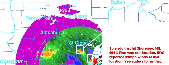
with, but they would also be so rain-wrapped that you were asking for trouble. We met in Hudson at about 3:30pm and decided to head west into the twin cities to sit the storm out at my place. Before we left Hudson we stopped at the rest area in Hudson and looked at the DTN radar they had there. We noticed some severe cells moving north. They had a bow echo look to them. So we decided to try to get to the edge of the storms and watch them go by. As we headed west we got off of I-94 and onto 694. Looking to the south we could see some very ominous looking clouds. Structure was very obscured by rain, but the deep dark color to them told us we were in a bad spot. At about 4:30pm I decided we had to get out of the way. It was rush hour traffic and I decided to bypass it. I took the emergency lane aside the stopped traffic to get to some shelter. I turned off on Rice Street in Shoreview. There was a gas station on the corner so I figured we could flee there. But before we took shelter I wanted to go down the road next to the gas station to try to get a look at what was behind the trees. As we got to a dead end the trees cleared out and we could see a thick tornado comming right across 694 moving right towards us. Tim looked behind us and saw yet another smaller tornado. ---------------------------------------------------------------------------------------------------------------------------- ----------------------------------------------------------------------------------------------------------------------------
 We opted at this time to try to get back to the gas station. As I tried to turn around the wind began to pick up. A huge gust of wind shook my truck and began to rock the vehicle. As I saw in a storm chase video, I chose to face the vehicle towards the wind so as the wind would not catch the broad side of the truck and turn us over. The wind subsided slightly enough so that I could continue trying to get to the gas station which was less than a block away. As we drove down the road a tree fell across it, we had to veer around the fallen debris and get to the Gas station. I pulled into a car wash that they had for fear that I would have hail damage to my beautiful purple Dakota. (sarcastic) We ran to the gas station and as we did the power went out. Others in the gas station told us of how they're vehicles windows were blown out from the winds. After a while the storm passed and we continued down 694 to see the destruction of the tornadoes. We documented a turned over 18wheeler less than 1 mile from our location. Further down the road a huge exit sign had colapsed onto the interstate. All along that mile stretch or less than a mile stretch of road we found vehicles with no windows and lots of debris from a company to the south of the highway that had lost it roof in the tornado. Later that evening I went back to the area that seemed to get hardest hit by the tornadoes. I discovered two patches on the ground on the west side of the building that lost its roof that had 12' x 8' areas of cut grass in almost a triangle type shape. The areas were about 25' apart from each other and appeared to have about 6" of dirt dug out of the ground and sucked up into the tornado in the part of the triangle that appeared to have been where the tornado initially touched down. Grass blades were completely cut off. This was the most exciting tornado I have witnessed up to this point. A fair one to our west and a smaller one to our east. We have very poor pictures of both, but not worth posting here. This was my 4th year chasing while I was still learning how to use a manual 35mm camera. All of the images were dark and blurry.
BULLETIN - EAS ACTIVATION REQUESTED TORNADO WARNING NATIONAL WEATHER SERVICE TWIN CITIES/CHANHASSEN MN 451 PM CDT FRI MAY 15 1998
THE NATIONAL WEATHER SERVICE IN THE TWIN CITIES/CHANHASSEN HAS
SOUTHEASTERN ANOKA COUNTY IN EAST CENTRAL MINNESOTA NORTHERN RAMSEY COUNTY IN EAST CENTRAL MINNESOTA NORTHWESTERN WASHINGTON COUNTY IN EAST CENTRAL MINNESOTA
ARDEN HILLS AND SHOREVIEW IN NORTHERN RAMSEY COUNTY. THE STORM WAS MOVING NORTH AT 60 MPH.
CIRCLE PINES FOREST LAKE WHITE BEAR LAKE
0440 PM    SHOREVIEW                 MN   89 MPH TSTM GUST
05/15/98   RAMSEY                         MEASURED AT I694 AND RICE
                                          STREET...ROOFS PARTIALLY
                                          DESTROYED
NWS DAMAGE SURVEY RESULTED IN TORNADO TOUCHDOWN IN ROSEVILLE AROUND 440 PM AND TRAVELLED NORTH THROUGH SHOREVIEW...NORTH OAKS...LINO LAKES AND LIFTED OFF IN EXTREME EASTERN BLAINE. THE TORNADO WAS ON THE GROUND FOR 12 MILES AND HAD A MAXIMUM WIDTH OF 1/5 MILE...AND WAS RATED AN F1.
|