|
John Stolfa and myself (Andy Revering) travelled from our homes to meet in Des Moines, IA at
about 8:30am Monday morning. From there we travelled west on I-80 through Omaha, Lincoln and
adventually made it to the town of Grand Island. As we continued to drive we noticed some towers going up to our west. We gave our "Base" man a call (Doug Raflik in Oshkosh, WI) to see if he could give us some information on those cells we were seing. He advised us that they were going severe, and were just to the east of the town of Gothenburg, NE on I-80. The cell was moving ENE.
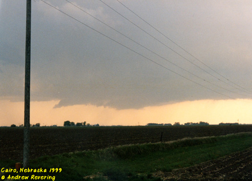 At this point we noticed the flank of the storm was developing more cells along it. Closing us in ahead of and to the SE of the storm. If a line were to develop to the west we would be up shit creek in a rowboat without any oars so we decided we needed to punch the rain free base and hope a tornado didnt drop as we tried to do it. Moving slowly to the N on 11 we heard that there was a tornado on the ground near Hazzard, NE to our WNW about 25 miles away at 6:28pm. Another tornado dropped near Rockville, NE. Golfball sized hail being reported in the area. Lots of scuds were visible as we slowly moved N on 11 trying to keep out of the storm and still trying to keep safe, hoping to find a hole to punch back west through. At 6:31pm people were passing us going into the supercell. We crawled along letting it pass to our north hoping we could get behind the rain-free base. A tornado was spotted on the ground 6 miles north of Boelus, NE which was 10 miles to the north of us, moving NE slightly away from us. A severe thunderstorm warning was then issued in our county to our south in Hall county. As we moved slowly N we came to a intersection and decided to move east. At that point something made me choose to get out of the truck and look up over us since we were under the rain-free base. As I did that I saw a huge rotation above us. We got in the vehicles and bucked east at 70mph. We moved into downtown Grand Island, NE and got stuck in town. Sirens started to blow in town and heavy rain started in for a short time. To our west a line developed and was closing in on us fast. The storm was backbuilding and heading towards us. We could no longer punch through anything. We just had to keep ahead of the storm. We went east on I-80 to 14 to the town of Aurora. On the corner of I-80 and 14 we found 2 other chase vehicles there. As we sat there 2 more showed up, 4 drove by and as we left yet another showed up. All told at least 20 individual chasers ended up at that intersection. We decided to drive south on 14 to avoid a hail shaft that was producing 1" diameter hail that was heading our way, so we departed from the huge chaser gathering. As we moved south we ran into two more chase vehicles. 2 vans with SKYWARN painted on them.
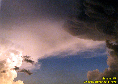 Moving south we saw more wall clouds. We headed west a bit to get behind the cell that was producing the large hail so we could see a beautiful funnel cloud. This funnel was so low to the ground it could have very likely been a tornado, but we were so far away it was hard to tell if there was a debris cloud. Night came quickly and this chase ended with at least 2 funnels, possibly a touchdown.
|