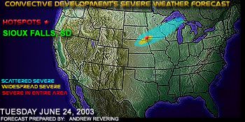
 The night before 6/24/03, I made a forecast with the primary focus for severe weather development to be between O'Neill, NE and Sioux Falls, SD, as shown above in the map I created and posted for that day. Here is a bit of the setup from this day:
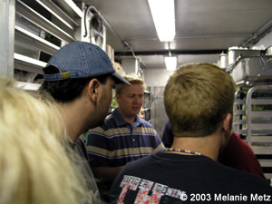
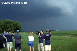
This day I went out with Peggy Willenberg, Melanie Metz, Brad Nelson and Rob Koch. Rob and I rode together while the other three took Peggy's 'Stormtours.com chase vehicle'. It just so happened that a KSTP news crew was following us out that day to do a story on StormTours.com. Rob Koch was not involved with this, just wanted a relaxing chase. Everyone was surprisingly in agreement about the target. We headed without question toward Sioux City and then off with the intent to get near O'Neill after looking at some morning data and modifying our original targets. About half way between Norfolk and O'Neill we noticed some towers going up just on our east side. They looked very willing to go but got a little fuzzy around the edges once they got so high. Nothing was going on visually to our west, so we just hung there for a bit to watch and see what happened. A guy working where we stopped said he owned the gas station in the nearest town of Orchard, NE and had a DTN station we could check out. So we did. Upon quick glance we saw a couple blips on radar just to our east. That was enough to send us rolling. About the same time Tim Vasquez said that we might as well go for those cells since they were the best thing in the area. We were now in chase mode. It wasn't long before a severe t-storm warning was issued, and then quickly replaced with a tornado warning. In an effort to get into position without worry about crossing the Missouri River, we dove north on 81 to cross into SD at Yankton. Cells at this point were said to be moving NNE. In Yankton we went east toward Vermillion. Near the city of Meckling, SD we stopped to get some video and found 2" hail scattered around in the ditch.
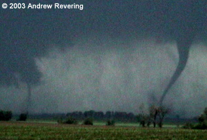
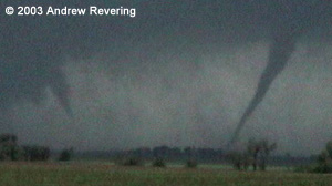
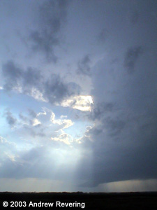
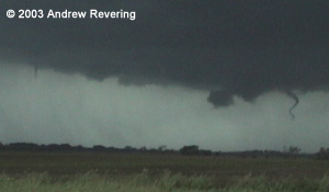
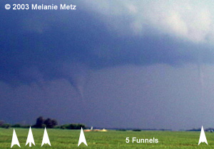
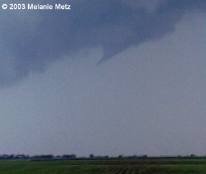
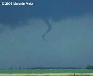
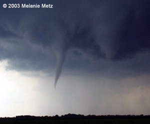
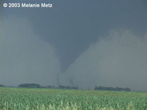
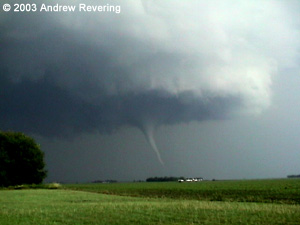
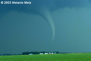
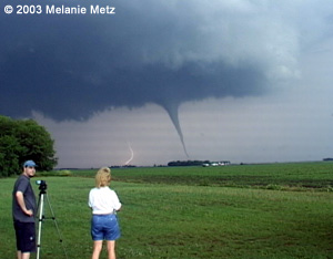
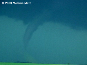
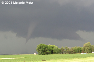
From this point on we saw many funnels and tornadoes. Below are some of the funnels we saw in no particular order.
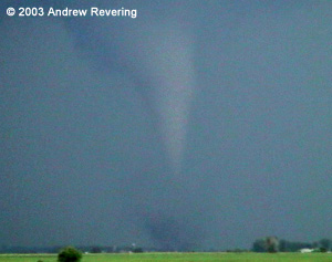
Tornado #3 persisted for a while and took on a couple shapes. The below 2 pictures are of the same circulation which was consistently on the ground, therefore I'm counting this as the same tornado.
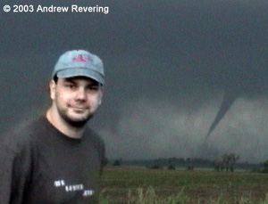
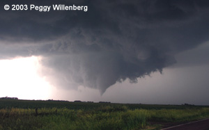
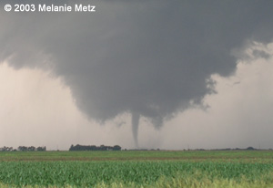
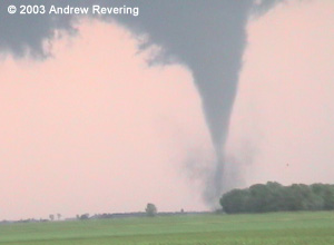
Tornado #4 was probably the prettiest tornado of the day. The next 4 images are all of that tornado from various perspectives. Note the one photo with the lightning in the background illuminating the atmosphere.
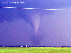
Tornado #5 was getting closer to sunset, so the contrast in the photos began to diminish considerably. Note the pinkish background in one of the next 3 photos. That color is not enhanced, but rather was due to a lightning strike somewhere behind the tornado. The purplish photo is enhanced and was done so due to poor contrast.
Tornadoes #9 and #10 dropped at the same time and were just gorgeous as we could just see their sillouette dancing in the fields just before sunset. From our location where we were videotaping, we had debris all around us. Sheet metal was all over the adjacent fields and one power pole had been knocked down. Farther up the road, after we witnessed these two dancing tornadoes, we had a rather large tree blocking an entire road.
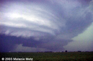
At the end of the day we were able to get a view of an amazing mesocyclone. This image is slightly color enhanced for better contrast since it was taken just after sunset.
After the chase we headed off to Sioux Falls to eat at a Chili's. In the process a tornado from this SAME supercell was spotted just a few miles west of the restaurant. We were all hurded into the freezer.
Below is a statement released by the National Weather Service in Sioux Falls regarding the severity of the damage.
F2 TORNADO (113-157 MPH) 2 MILES EAST OF DAVIS...TURNER COUNTY...AT
829 PM.  TORNADO MOVED FROM SOUTH TO NORTH.

F1 TORNADO (73-112 MPH) 2 MILES NORTH OF DAVIS...TURNER COUNTY...AT
757 PM.  TORNADO MOVED FROM SOUTHEAST TO NORTHWEST.

F1 TORNADO (73-112 MPH) 1 MILE NORTHWEST OF CENTERVILLE TO 3 MILES
NORTHWEST OF CENTERVILLE...TURNER COUNTY...AROUND 800 PM.  TORNADO
CURVED FROM SOUTHEAST TO NORTHWEST.

F1 TORNADO (73-112 MPH) 6 MILES NORTHWEST OF BERESFORD...LINCOLN
COUNTY...AROUND 810 PM.  TORNADO MOVED FROM SOUTHEAST TO NORTHWEST.

F1 TORNADO (73-112 MPH) 4 MILES NORTHWEST OF CENTERVILLE...TURNER
COUNTY...AROUND 815 PM.  TORNADO MOVED FROM SOUTHEAST TO NORTHWEST.

F1 TORNADO (73-112 MPH) 8 MILES NORTHWEST OF BERESFORD...LINCOLN
COUNTY...AROUND 830 PM.  TORNADO MOVED FROM SOUTHWEST TO NORTHEAST.

F1 TORNADO (73-112 MPH) WEST SIDE OF VIBORG...TURNER COUNTY...
AROUND 1040 PM.  TORNADO MOVED FROM SOUTHWEST TO NORTHEAST.

F0 TORNADO (40-72 MPH) SOUTHEAST CENTERVILLE...TURNER COUNTY...
AROUND 720 PM.  BRIEF TOUCHDOWN.

F0 TORNADO (40-72 MPH) SOUTHEAST CENTERVILLE...TURNER COUNTY...
AROUND 725 PM.  BRIEF TOUCHDOWN.

F0 TORNADO (40-72 MPH) PARKER...TURNER COUNTY...BETWEEN 915 PM AND
930 PM.  TORNADO MOVED FROM SOUTH TO NORTH.
|
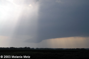
 Tornado warnings still wailing and reports now starting to come in, we went north out of Vermillion. Here is where we got the first view of the updraft that would produce our biggest collective chase day to date. The updraft was straight as an arrow and hard as a rock. This structure was not only beautiful but quite apparent had the potential to produce something big.
 At the base of the updraft was a lowering which was just gorgeous and virtually had a flag on itself saying "watch out". We were somewhere near Clay Point, SD at this stage of the game.
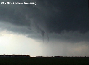
 Tornado #6 was the last tornado that we were able to see together as a group. We came across some damage to a house and emergency management was trying to get us to turn around. We did, but Peggy's vehicle was let through. So Rob Koch and I were on our own. Fortunately we all managed to see the same show, just from different angles. This tornado was on the ground visible from the damaged home while the emergency crews were doing their job. What a scarry situation. Fortunately everyone at the home was ok.
 Tornado #7 was one that Rob and I missed visually as we were heading south away from the damage path while Peggy, Mel & Brad, along with the KSTP news crew were able to wiggle their way through the damage. This tornado occured just seconds after the previous one dropped. It was nearly identical and nearly in the same spot, but after reviewing video, it appears that it clearly was a different circulation which developed just to the northeast of Tornado #6, after it dissipated.
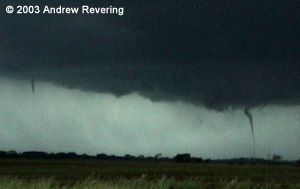 Tornado #8 was a tornado that I believe Peggy, Mel and Brad missed. From our advantage point it was quite close to us as we headed west and north of the other team's position. This was a very brief touchdown coming from the same action area as the last two tornadoes would come from. Again, video clearly shows this circulation develop, touch down with some debris, dissipate and shortly after two more tornadoes develop... #s 9 and 10. With tornado #8, note the needle funnel to the left.